
File:Briskeby map 1900.jpg

Size of this preview: 685 × 600 pixels. Other resolutions: 274 × 240 pixels | 548 × 480 pixels | 700 × 613 pixels.
Original file (700 × 613 pixels, file size: 683 KB, MIME type: image/jpeg)
| This is a file from the Wikimedia Commons. Information from its description page there is shown below. Commons is a freely licensed media file repository. You can help. |
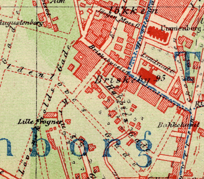
| Description | Briskeby, Oslo. | ||||
| Date | s.d. - [1900] | ||||
| Source | «Nyeste Kart over Kristiania, Forlagt af A. Sabro, Kristiania. Det private Opmaalings Kontor.» | ||||
| Author | Scanned by Mahlum | ||||
| Permission (Reusing this file) |
|
||||
File history
Click on a date/time to view the file as it appeared at that time.
| Date/Time | Thumbnail | Dimensions | User | Comment | |
|---|---|---|---|---|---|
| current | 15:23, 30 March 2008 | | 700 × 613 (683 KB) | Mahlum | {{Information |Description=Briskeby, Oslo. |Source= «''Nyeste Kart over Kristiania'', Forlagt af A. Sabro, Kristiania. Det private Opmaalings Kontor.» |Date=s.d. - [1900] |Author= Scanned by Mahlum |Permission= {{PD-old}} |other_versions |
File usage
The following page uses this file:
Global file usage
The following other wikis use this file:
- Usage on no.wikipedia.org