
File:Hare Bay Islands ER.jpg

Size of this preview: 756 × 600 pixels. Other resolutions: 303 × 240 pixels | 605 × 480 pixels | 958 × 760 pixels.
Original file (958 × 760 pixels, file size: 94 KB, MIME type: image/jpeg)
| This is a file from the Wikimedia Commons. Information from its description page there is shown below. Commons is a freely licensed media file repository. You can help. |
Summary
| Description |
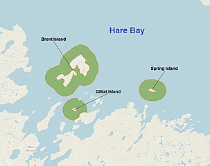
English: Map of Hare Bay Islands Ecological Reserve, Newfoundland and Labrador, Canada. |
| Date | |
| Source | w:MapBox and w:OpenStreetMap; including some own additions. |
| Author | Users of OpenStreetMap, MapBox and own work. |
Licensing
This file is licensed under the Creative Commons Attribution 2.5 Generic license.
- You are free:
- to share – to copy, distribute and transmit the work
- to remix – to adapt the work
- Under the following conditions:
- attribution – You must give appropriate credit, provide a link to the license, and indicate if changes were made. You may do so in any reasonable manner, but not in any way that suggests the licensor endorses you or your use.
File history
Click on a date/time to view the file as it appeared at that time.
| Date/Time | Thumbnail | Dimensions | User | Comment | |
|---|---|---|---|---|---|
| current | 15:37, 20 February 2019 | | 958 × 760 (94 KB) | Ycleymans | User created page with UploadWizard |
File usage
The following page uses this file:
Global file usage
The following other wikis use this file:
- Usage on de.wikipedia.org
- Usage on nl.wikipedia.org