
File:Ile de France.svg

Size of this PNG preview of this SVG file: 777 × 581 pixels. Other resolutions: 320 × 239 pixels | 640 × 479 pixels | 1,024 × 766 pixels | 1,280 × 957 pixels | 2,560 × 1,914 pixels.
Original file (SVG file, nominally 777 × 581 pixels, file size: 95 KB)
| This is a file from the Wikimedia Commons. Information from its description page there is shown below. Commons is a freely licensed media file repository. You can help. |
Summary
| Description |
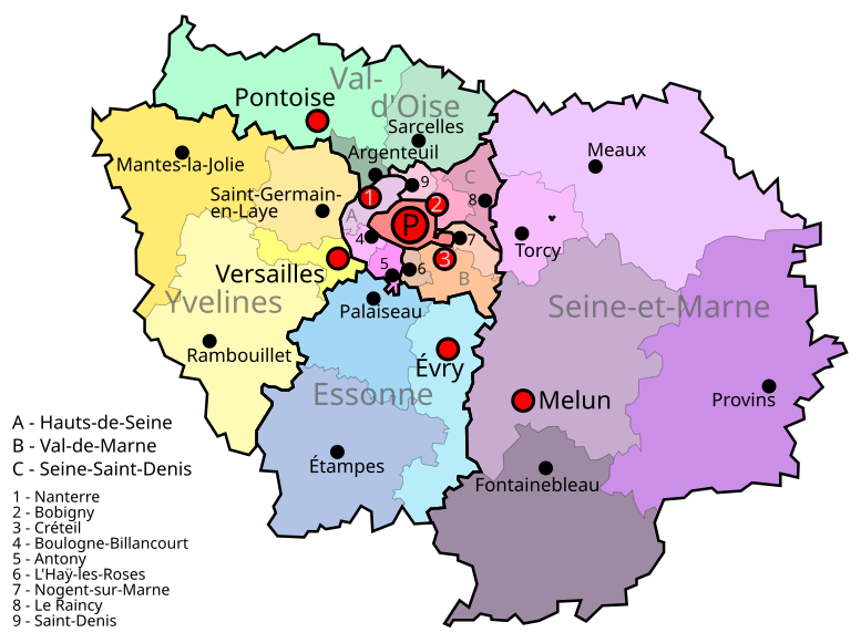
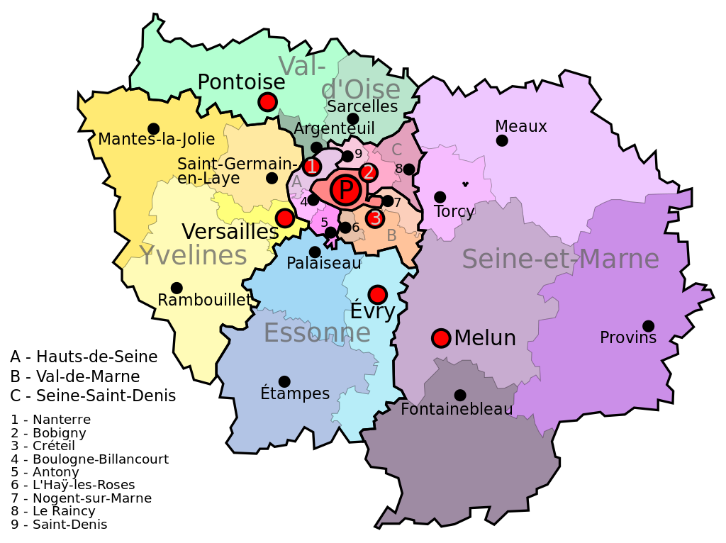
English: Map of the French region of Île de France. The largest color blocks with thick black lines are the eight departments: Large red P for Paris, A, B, C, and all-caps light grey entities (e.g. Val-d'Oise). Smaller color blocks are the arrondissments of the department. Red dots are the communes that are the prefecture (capital of the department and the arrondissment). Black dots are the subprefectures (capitals of the arrondisments, which have the same name). Paris is both a commune and a department, and is also the prefecture (capital) of the region and the capital of the country.
Español: Mapa de Île de France |
| Date | |
| Source | Own work |
| Author | Jome |
| Camera location | | View this and other nearby images on: OpenStreetMap |
|---|
Licensing
| I, the copyright holder of this work, release this work into the public domain. This applies worldwide. In some countries this may not be legally possible; if so: I grant anyone the right to use this work for any purpose, without any conditions, unless such conditions are required by law. |
File history
Click on a date/time to view the file as it appeared at that time.
| Date/Time | Thumbnail | Dimensions | User | Comment | |
|---|---|---|---|---|---|
| current | 16:19, 9 July 2011 | | 777 × 581 (95 KB) | AnonMoos | adjust margins |
| 15:32, 9 July 2011 |  | 600 × 600 (96 KB) | Sémhur | Black Box Bug removed | |
| 08:48, 7 June 2010 |  | 600 × 600 (112 KB) | Jome | {{Information |Description={{en|1=Île de France map}} {{es|1=Mapa de Île de France}} |Source={{own}} |Author=Jome |Date= |Permission= |other_versions= }} Category:Maps |
File usage
The following page uses this file:
Global file usage
The following other wikis use this file:
- Usage on bn.wikipedia.org
- Usage on el.wikipedia.org
- Usage on fr.wikipedia.org
- Île-de-France
- Modèle:Sommaire arrondissements de Paris
- Modèle:Infobox Voie de Paris
- Modèle:Géolocalisation/Paris
- Modèle:Carte/Paris
- Modèle:Infobox Voie de Paris/Documentation
- Modèle:Chronologie de Paris
- Wikipédia:Atelier graphique/Cartes/Archives/Demandes mises en sommeil/France
- Modèle:Infobox Porte de Paris
- Modèle:Infobox Porte de Paris/Documentation
- Modèle:Pays & territoires de naissance des Franciliens
- Modèle:Country data Paris
- Modèle:Tableau des superficies successives de Paris
- Modèle:Agglomération parisienne
- Modèle:Évolution de la population en Île-de-France
- Modèle:Courbe d'évolution de la population en Île-de-France
- Modèle:Évolution de la population de l'Île-de-France par département
- Modèle:Modèles liés Paris
- Modèle:Tableau Démographie Paris
- Modèle:Histogramme population Paris
- Modèle:Infobox Voie de Paris/Bac à sable
- Usage on id.wikipedia.org
- Usage on it.wikipedia.org
- Usage on lld.wikipedia.org
- Usage on mn.wikipedia.org
- Usage on uz.wikipedia.org
- Usage on vls.wikipedia.org