
File:World elevation map.png

Size of this preview: 800 × 400 pixels. Other resolutions: 320 × 160 pixels | 640 × 320 pixels | 1,024 × 512 pixels | 1,280 × 640 pixels | 2,560 × 1,280 pixels | 21,600 × 10,800 pixels.
Original file (21,600 × 10,800 pixels, file size: 71.79 MB, MIME type: image/png)
| This is a file from the Wikimedia Commons. Information from its description page there is shown below. Commons is a freely licensed media file repository. You can help. |
Summary
| Description |
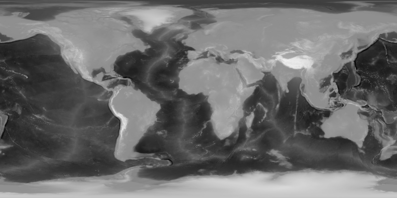
English: This is an height map of the planet earth at approximately 1.8km per pixel (at the equator). It uses an Equirectangular projection, so it's well suited for usage in mapping software.
It was done by combining two images from Nasa's Blue Marble collection, the [Topography](https://visibleearth.nasa.gov/images/73934/topography) and [Bathymetry](https://visibleearth.nasa.gov/images/73963/bathymetry) maps. These images were made by Jesse Allen, NASA's Earth Observatory, using data from the General Bathymetric Chart of the Oceans (GEBCO) produced by the British Oceanographic Data Centre. These images are, according to their Image use policy [freely available for re-publication or re-use, including commercial purposes](https://visibleearth.nasa.gov/image-use-policy). Both images were combined over a gray background. The gray is #8f8f8f which was chosen for having a brightness of 56% which is the ration between of sea level between added height the Mt Everest and Mariana Trench. Bathymetry images were added as a Multiply blend, meaning it's subtracted from the sea level and Topography using a Screen Blend meaning it's added. |
| Date | |
| Source | Own work |
| Author | Avsa |
| Other versions |
|
_(alterative_version).png)
Licensing
I, the copyright holder of this work, hereby publish it under the following license:
This file is licensed under the Creative Commons Attribution-Share Alike 4.0 International license.
- You are free:
- to share – to copy, distribute and transmit the work
- to remix – to adapt the work
- Under the following conditions:
- attribution – You must give appropriate credit, provide a link to the license, and indicate if changes were made. You may do so in any reasonable manner, but not in any way that suggests the licensor endorses you or your use.
- share alike – If you remix, transform, or build upon the material, you must distribute your contributions under the same or compatible license as the original.
File history
Click on a date/time to view the file as it appeared at that time.
| Date/Time | Thumbnail | Dimensions | User | Comment | |
|---|---|---|---|---|---|
| current | 14:33, 28 July 2023 | | 21,600 × 10,800 (71.79 MB) | Avsa | Inverted the grey base from a 44% to a 56%: the Mariana Trench is about 2km deeper than Everest is high, so there should be more details on the oceanic bits. |
| 14:10, 28 July 2023 |  | 21,600 × 10,800 (68.22 MB) | Avsa | Uploaded own work with UploadWizard |
File usage
The following pages on the English Wikipedia use this file (pages on other projects are not listed):