
Portal:Kent/Sandbox
DesktopMobile
Test of: Transclude files as random slideshow/sandbox
-
-
 The coat of arms of Kent County Council (from Kent)
 -
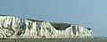 The White Cliffs of Dover (from Kent)
 -
-

-
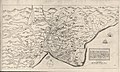 A map of Romney Marsh "The history of imbanking and drayning" by William Dugdale (1662). (from Kent)
 -
 Canterbury Cathedral (from Kent)
 -
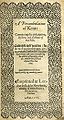 Title page of William Lambarde's Perambulation of Kent (completed in 1570 and published in 1576), a historical description of Kent and the first published county history (from Kent)
 -

-
-
 Geological cross-section of Kent, showing how it relates to major towns (from Kent)
 -
 Hand-drawn map of Kent, Sussex, Surrey and Middlesex from 1575. (from Kent)
 -

-
 View of the White Cliffs of Dover from France (from Kent)
 -
 Kent, as it appears in the Anglo-Saxon Chronicle between 11th and 12th centuries (from Kent)


Apr2006.jpg)

.jpg)


Test of: Transclude linked excerpts as random slideshow/sandbox
-
 Folkestone and Hythe is a local government district in Kent, England. It lies in the south-east of the county, on the coast of the English Channel. The district was formed in 1974 and was originally named Shepway after one of the ancient lathes of Kent, which had covered a similar area. The district was renamed in 2018. The council is based in Folkestone, the district's largest town. The district also includes the towns of Hawkinge, Hythe, Lydd and New Romney, along with numerous villages and surrounding rural areas. (Full article...)
 -
High Speed 1 (HS1), legally the Channel Tunnel Rail Link (CTRL), is a 109.9-kilometre (68.3-mile) high-speed railway linking London with the Channel Tunnel. (Full article...)
-
Elections to Kent County Council were held on 6 May 2021, alongside other local elections. (Full article...)
-
The Borough of Dartford is a local government district with borough status in the north-west of the county of Kent, England. It is named after its main town of Dartford, where the council is based. Other notable settlements include Greenhithe, Stone and Swanscombe, along with an emerging new town at Ebbsfleet, and a number of smaller villages. It also includes Bluewater, one of the UK's largest shopping centres. The borough lies just outside the administrative boundary of Greater London, but a sizeable part of it lies within the M25 motorway which encircles London. Many of the borough's urban areas form part of the Greater London Built-up Area. The borough had a population of 116,800 at the 2021 census. (Full article...)
-
Kent is a traditional county in South East England with long-established human occupation. (Full article...)
-
-
The North Sea lies between Great Britain, Denmark, Norway, Germany, the Netherlands, Belgium and France. An epeiric sea on the European continental shelf, it connects to the Atlantic Ocean through the English Channel in the south and the Norwegian Sea in the north. It is more than 970 kilometres (600 mi) long and 580 kilometres (360 mi) wide, covering 570,000 square kilometres (220,000 sq mi). (Full article...)
-
A census of the population of the United Kingdom is taken every ten years. The 2011 census was held in all counties of the UK on 27 March 2011. It was the first UK census which could be completed online via the Internet. The Office for National Statistics (ONS) is responsible for the census in England and Wales, the General Register Office for Scotland (GROS) is responsible for the census in Scotland, and the Northern Ireland Statistics and Research Agency (NISRA) is responsible for the census in Northern Ireland. (Full article...)
-
Scotland (Scots: Scotland; Scottish Gaelic: Alba) is a country that is part of the United Kingdom. It contains nearly one-third of the United Kingdom's land area, consisting of the northern part of the island of Great Britain and more than 790 adjacent islands, principally in the archipelagos of the Hebrides and the Northern Isles. To the south-east, Scotland has its only land border, which is 96 miles (154 km) long and shared with England; the country is surrounded by the Atlantic Ocean to the north and west, the North Sea to the north-east and east, and the Irish Sea to the south. The population in 2022 was 5,439,842. Edinburgh is the capital and Glasgow is the largest of the cities of Scotland. (Full article...)
-
Greater London is an administrative area in England, coterminous with the London region, containing most of the continuous urban area of London. It contains 33 local government districts: the 32 London boroughs, which form a ceremonial county also called Greater London, and the City of London. The Greater London Authority is responsible for strategic local government across the region, and regular local government is the responsibility of the borough councils and the City of London Corporation. Greater London is bordered by the ceremonial counties of Hertfordshire to the north, Essex to the north-east, Kent to the south-east, Surrey to the south, and Berkshire and Buckinghamshire to the west. (Full article...)
-
Allington is an almost entirely modern village situated alongside the sides of the A20 road west of Maidstone in Kent, England. It is part of the built-up area of Maidstone. (Full article...)
-
Royal Tunbridge Wells is a town in Kent, England, 30 miles (50 kilometres) southeast of central London. It lies close to the border with East Sussex on the northern edge of the High Weald, whose sandstone geology is exemplified by the rock formation High Rocks. The town was a spa in the Restoration and a fashionable resort in the mid-1700s under Beau Nash when the Pantiles, and its chalybeate spring, attracted visitors who wished to take the waters. Though its popularity as a spa town waned with the advent of sea bathing, the town still derives much of its income from tourism. (Full article...)
-
The River Medway is a river in South East England. It rises in the High Weald, West Sussex and flows through Tonbridge, Maidstone and the Medway conurbation in Kent, before emptying into the Thames Estuary near Sheerness, a total distance of 70 miles (113 km). About 13 miles (21 km) of the river lies in East Sussex, with the remainder being in Kent. (Full article...)
-
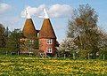
An oast, oast house (or oasthouse) or hop kiln is a building designed for kilning (drying) hops as part of the brewing process. Oast houses can be found in most hop-growing (and former hop-growing) areas, and are often good examples of agricultural vernacular architecture. Many redundant oast houses have been converted into houses. The names "oast" and "oast house" are used interchangeably in Kent and Sussex, but in Surrey, Hampshire, Herefordshire and Worcestershire they are called "hop kilns". (Full article...)
-
Tonbridge Juddians Rugby Football Club is an English rugby union team based in Tonbridge in Kent. The club runs four senior teams, a ladies side and the full range of junior teams. The first XV play in National League 2 East for the 2022–23 season having been relegated from National League 1, the previous season. (Full article...)
-
Rochester Castle stands on the east bank of the River Medway in Rochester, Kent, South East England. The 12th-century keep or stone tower, which is the castle's most prominent feature, is one of the best preserved in England or France. (Full article...)
-
Jack Cade's Rebellion was a popular revolt in 1450 against the government of England, which took place in the south-east of the country between the months of April and July. It stemmed from local grievances regarding the corruption, maladministration and abuse of power of the king's closest advisors and local officials, as well as recent military losses in France during the Hundred Years' War. Leading an army of men from south-eastern England, the rebellion's leader Jack Cade marched on London in order to force the government to reform the administration and remove from power the "traitors" deemed responsible for bad governance. Apart from the Cornish rebellion of 1497, it was the largest popular uprising to take place in England during the 15th century. (Full article...)
-
Swanley is a town and civil parish in the Sevenoaks District of Kent, England, 16 miles (26 km) southeast of central London, adjacent to the Greater London boundary and within the M25 motorway periphery. The population at the 2021 census was 17,826. (Full article...)
-
Charles John Huffam Dickens (/ˈdɪkɪnz/; 7 February 1812 – 9 June 1870) was an English novelist, journalist, short story writer and social critic. He created some of literature's best-known fictional characters, and is regarded by many as the greatest novelist of the Victorian era. His works enjoyed unprecedented popularity during his lifetime and, by the 20th century, critics and scholars had recognised him as a literary genius. His novels and short stories are widely read today. (Full article...)
-
The Reformation, also known as the Protestant Reformation and the European Reformation, was a major theological movement or period or series of events in Western Christianity in 16th-century Northwestern Europe that posed a religious and political challenge to the papacy and the authority of the Catholic Church. Towards the end of the Renaissance, the Reformation marked the beginning of Protestantism and in turn resulted in a major schism within Western Christianity. (Full article...)
-
-
The New Naturalist Library (also known as The New Naturalists) is a series of books published by Collins in the United Kingdom, on a variety of natural history topics relevant to the British Isles. The aim of the series at the start was: "To interest the general reader in the wild life of Britain by recapturing the inquiring spirit of the old naturalists." An editors' preface to a 1952 monograph says: "An object of the New Naturalist series is the recognition of the many-sidedness of British natural history, and the encouragement of unusual and original developments of its forgotten or neglected facets." (Full article...)
-
-
Penge was a civil parish and a local government district located to the southeast of London, England. It included the settlements of Penge, Anerley and part of Crystal Palace. It was part of the London postal district, Metropolitan Police District and, from 1933, the London Passenger Transport Area. In 1965 the urban district was abolished by the London Government Act 1963 and it became part of Greater London, being combined with other districts to form the London Borough of Bromley. (Full article...)
-
Thanet /ˈθænɪt/ is a local government district in Kent, England. The council is based in Margate and the district also contains the towns of Broadstairs, Ramsgate and Westgate-on-Sea, along with several villages. It takes its name from the Isle of Thanet, a former island which gradually became connected to the mainland between the 12th and 16th centuries. (Full article...)
